
Travelling from San Salvador to Santa Ana offers more than a city drive. It opens the door to one of El Salvador’s most scenic volcanic journeys. Most of the drive between San Salvador and Santa Ana follows CA-1, also known as the Carretera Panamericana. When you add the volcano loop, you move between fast highway lanes and steep mountain access roads, climbing to about 1,950 metres at El Boquerón and then up into the Los Volcanes area at Cerro Verde.
Our guide helps travellers get simple directions, realistic timing, and the technical details, including road names, park hours, and how guided hikes work. You will also learn why these volcanoes are best enjoyed with a rental car.
Distance: ~75 km
Driving Time: 1–1.5 hours (direct), full-day (with stops)
Best For: Adventure seekers, nature lovers
Must-Have: A reliable
The direct drive from San Salvador to Santa Ana is about an hour in light traffic, but the full volcano route is best planned as a full day or overnight because it adds detours and hiking time. Navigation is simple. You follow CA-1 for the backbone of the trip, then take signed turn-offs for El Boquerón, Lake Coatepeque, and Cerro Verde.
If you drive straight from San Salvador to Santa Ana, the trip is commonly listed at about 59 minutes on the Carretera Panamericana (CA-1), with the city-to-city distance about 60 to 75 kilometres. For the volcano route, you are not just going to Santa Ana. You are doing a loop with extra climbs and descents:
Road surfaces on the main links are generally paved, but you should still drive defensively near town edges. Here, speed bumps can appear suddenly and lane flow can feel less predictable than in Europe or North America. A simple rule is to start driving in daylight. Avoid inter-city travel at night and stick to major roads and highways when possible.
If you are searching for the best road trips in El Salvador, this volcano route is a top pick. You get three “big natural icons” in one line: a city volcano (El Boquerón), a crater lake (Coatepeque), and the country’s highest volcano hike (Santa Ana/Ilamatepec). Unlike long cross-country drives, you are never too far from services, towns, or a place to stop for food.
This route combines driving and hiking, so your plan needs to match both road time and your energy for walking at altitude. The highest physical point is Santa Ana Volcano (Ilamatepec), which reaches 2,381 metres above sea level.
For clearer skies and better chances of crater views, the drier months (November to April) are ideal for volcano hiking in this region. Clouds form quickly over the mountains, and rain can make paths slippery and views obscured by mist.
That said, the route works all year if you start early and stay flexible. In wetter months, plan for more cloud cover at Cerro Verde and Santa Ana Volcano, and keep extra time because roads can slow down in heavy rain.
Renting a car in El Salvador is the easiest way to do this route because stops are not always easy to link by public transport. A compact or mid-size car is usually the best choice because these vehicles are fuel-efficient, easy to handle in city traffic, and comfortable on the long stretches of CA-1.
If you plan to visit all the mountain stops, including El Boquerón and Cerro Verde, consider renting a small SUV or crossover. The higher ground clearance and stronger engine make steep climbs, tight bends, and uneven road sections more comfortable and controlled.
If you are travelling in a group or carrying extra gear for hiking, a larger SUV offers more space and stability, especially on winding mountain roads. Manual transmission cars are common and often cheaper. Choose automatic if you prefer an easier drive, particularly on steep terrain.
In general, you do not need a 4x4 for this route. However, a vehicle with good brakes, responsive handling, and enough power for uphill driving will make the journey smoother.
These stops turn a simple drive into a full experience, with short scenic walks, panoramic viewpoints, and one of the best volcano hikes in El Salvador. Plan your time so you can enjoy each stop without rushing.
San Salvador sits in a valley, so most routes out of the city involve either climbing into the hills or merging onto major roads like CA-1. If you start from the historic area, you can visit key sites, then drive out before traffic builds. If you have even one extra hour in the morning, San Salvador’s Historic Centre is an easy place to get a “first feel” of the country.
The National Palace is a well-known landmark in the Historic District and a key cultural and historical building for visitors. Nearby, the Metropolitan Cathedral is also a major site in the Historic Centre.
Do your shopping in the city, not in the mountains. In the volcano areas, there are small stalls and cafés, but your best choice for price and selection is still San Salvador.
El Boquerón National Park sits high on the San Salvador Volcano at roughly 1,950 metres above sea level, which is why it often feels cooler than the city below. It is a short and worthwhile stop on the San Salvador to Santa Ana route, offering a real volcano crater view with minimal walking.
El Boquerón is a natural oasis very close to the capital, because you can stand on a volcano rim and still be near a large city. You will get a view of the crater area and also see a smaller crater feature often called El Boqueroncito. You can enjoy wide overlooks of the surrounding landscapes.
Expect a relaxed, family-friendly atmosphere along the main paths, with cafés and viewpoints near the entrance. El Boquerón National Park is open daily from 8:00 a.m. to 5:00 p.m. Entry is typically low-cost. Entry is free for young children and older adults. A walk to the viewpoints takes about 25 minutes.
Lake Coatepeque is a volcanic caldera lake and one of the most striking stops along the San Salvador to Santa Ana drive. You can take photos at Lake Coatepeque from above and from the shore. For an above view, use viewpoints on the road toward Cerro Verde. For shore views, many restaurants and lakefront spots offer strong colour reflections in bright light.
Lake Coatepeque is a popular visitor area, so you will find many food options, from simple cafés to larger terrace restaurants along the shore. Finally, Lake Coatepeque offers kayaking, jet skiing, diving, fishing, and boat rides. If you plan to swim, choose areas where conditions are monitored, and avoid unknown entry points.
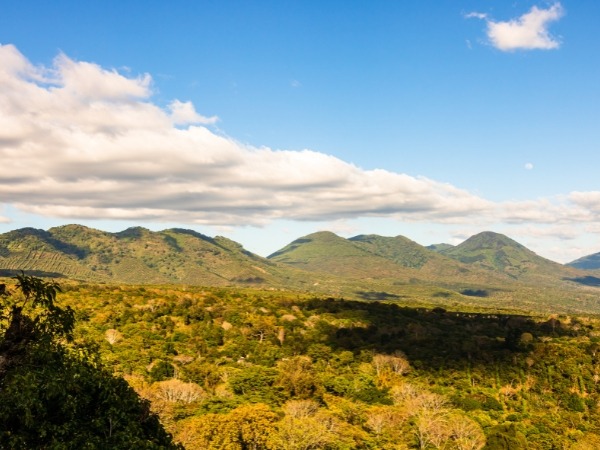
Cerro Verde is a scenic park and a base for hikes. It is part of the Los Volcanes area and is known for its cooler, misty climate. It features defined visitor areas, viewpoints, and interpretive trails. For larger hikes like Izalco or Santa Ana Volcano, this is the starting point with organized groups and guides.
From Cerro Verde viewpoints, you can see both volcanoes clearly. On clear days, you can also see Lake Coatepeque from above, one of the best panoramic scenes in El Salvador.
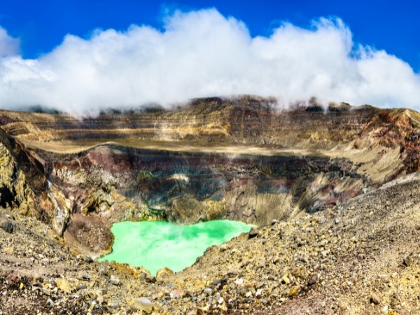
Santa Ana Volcano (Ilamatepec) is the highest volcano in El Salvador and the main highlight of the San Salvador to Santa Ana route. The hike is around 7.1 kilometres return with steady elevation gain.
The hike is moderate but still requires effort. The trail becomes more exposed and rocky near the top. Access is typically guide-controlled, with scheduled group departures for safety. At the summit, you will see a bright crater lake inside an active volcano. Views can include Lake Coatepeque, Izalco, and Cerro Verde, depending on conditions.
Santa Ana is located just off the Pan-American Highway. It is the perfect endpoint for the San Salvador to Santa Ana journey. After a day of nature, the city offers architecture, food, and a relaxed atmosphere.
Start near Parque Libertad. The Santa Ana Cathedral and National Theatre are key landmarks within walking distance. The city centre has cafés, restaurants, and bakeries. It is also a great place to try pupusas.
Choose accommodation with secure parking and walkable access to the centre. Santa Ana features historic buildings and strong architectural character, including its cathedral and theatre.
To make your journey from San Salvador to Santa Ana smooth and memorable, keep these expert tips in mind:
What to Pack: The mountain weather changes quickly. Pack sunscreen for the high altitude, sturdy hiking shoes for the volcanic terrain, a windbreaker as temperatures drop significantly at the summits, and plenty of water to stay hydrated.
Safety First: When approaching the Santa Ana city entrance, remain alert. Traffic can be heavy and unpredictable, so drive defensively and keep an eye out for sudden stops or lane changes.
Parking Smart: Always park your
Start Early: To beat the crowds and enjoy clear views from the volcano peaks, aim to depart San Salvador early in the morning.
This journey is less about reaching Santa Ana than about moving slowly, intentionally, and with small detours through the landscape. The road from San Salvador to Santa Ana rewards those who start early, stay flexible, and let the changing altitude, light, and scenery set the pace.
Rent a car in San Salvador with Final Rentals to explore the route on your own schedule and stop where the views pull you in. Select your pickup location, enter your travel dates, and choose a vehicle for your trip. Book and manage your car rental at any time. Download the Final Rentals app on Google Play and the App Store.
Yes, it is realistic if you start early and plan your time well. The Santa Ana Volcano hike takes around 3 to 3.5 hours, so treat it as your main activity. For a more relaxed experience, consider staying overnight near Santa Ana or Lake Coatepeque.
Yes, access is generally managed through guided groups for safety and navigation. Groups leave at scheduled times, so it is best to arrive early and secure a place.
Yes, many travellers complete this route safely by using major roads like CA-1 and travelling during daylight hours. Plan your journey carefully and avoid night driving for safety.